(Written for MSN's New Thinker's Index with Hyundai website, originally published here.)
Beautiful images that offer a new way of looking at the world from Bing Maps.
Bullfrog Bay Marina, Lake Powell, Utah

Bullfrog Bay is a popular spot for boaters who want to park up their houseboats in beautiful surroundings. From 17,000 feet above, however, the view becomes one of marshmallow clouds drifting across an ominous dark blue sky.
Cabinet Gorge Dam, Idaho

Thrown up in record time in the early 1950s to combat flooding, this arch dam remains a striking presence not far from the Idaho Highway in the US. Seen from above, it’s power over, and control of, the forces of nature are even more apparent as it keeps a tight grip on the natural flow of the river.
Carved animals in a field, Ghent

Not all farm fields have to be etched with the straight lines created by tractors going about their work. One imaginative farmer near Ghent, in the Flemish region of Belgium, has been doodling in one field. How many animals can you see?
Coastline of Cap d'Artrutx, Menorca, Spain

This tiny little village on the south west corner of the Spanish island of Menorca is an unassuming tourist spot with an array of hotels and villas. From above it’s a clash of patterned colour – swirls of different shades of brown mix with dull green, both lifted by the sparkling blue of the water – of both the pools and the sea.
Container ship on the River Lys, France
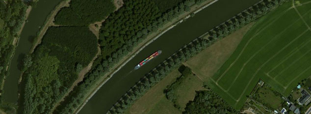
The River Lys is better known for being polluted due to the large amounts of industrial activity along its banks in Northern France and Belgium than it is for being a beauty spot. Yet seen from above, it regains its natural beauty, the presence of a container ship only adding a pleasing splash of colour.
Crazy Mountains, Montana

Home to a large array of fauna, including many a mountain goat and the occasional elusive wolverine, the Crazy Mountains are also a popular spot for hiking and mountaineering. Seen from above, however, they take on a menacing air – throbbing and undulating as if a bubbling hot tar pit.
Everglades National Park, Florida

One of the largest national parks in the US, the Everglades protects a fragile ecosystem and a number of endangered animals, such as the Florida panther and the American crocodile. From above it is representative of how we incorporate nature’s look into our own lives, the water creating beautiful patterns that wouldn’t look amiss on curtains or wallpaper.
East of Widnes, England

Widnes is a thriving industrial town in the north-west of England, a major centre of the chemical industry since the Industrial Revolution began in the mid-19th century. From above it is a clash of industry and nature, the circuit board of buildings nestling uncomfortably amongst the greenery.
Farm fields, Washington

The undulating landscape of Washington State in the US contributes to the unusual shapes formed in these farm fields, north of the small town of La Crosse. Looking down on these well-cultivated fields, you can imagine beautiful ancient carvings cut deep into sandstone, creating beautiful intricate patterns.
Farm fields, New Mexico

These circular markings look slightly odd seen from above – more like mysterious crop circles than the innocent farm fields in New Mexico, US that they are. The circular shape is becoming increasingly common due to the growing popularity of ‘central pivot irrigation’ – often used on more difficult undulating landscapes.
Farm fields, Ghent

These more typical farm fields in Ghent in Belgium have a stark uniformity to them when seen from above that takes away any natural feel you may have walking amongst them on the ground. Such is their precise tidiness, they are reminiscent of the chips and other components of a computer motherboard.
Farm fields, north of La Solana

From the air this dry and arid-looking land in central Spain doesn’t look capable of producing much in the way of fruit and vegetables. And yet the neatly arranged dots – well-organised amongst the random shapes of the fields themselves - are abundant olive trees, thriving in the hot Spanish climate.
Great Divide Basin, US

The Great Divide Basin is a huge area of land in the US – some 4,000 square miles – that serves as a catchment area for surface water, taking it through the land and out to the Pacific and Atlantic Oceans. The water has a striking effect on the land as it travels through, shaping it into patterned cuts and grooves seen in beautiful clarity from above.
Navy bombing target area, Nevada

Nevada – the driest state in the US – has still managed to make use of its large desert and semi-arid areas – as a bombing test site. The state has a long history of nuclear testing, but these buildings (looking like some sort of code, according to some conspiracy theorists) are used as navy bombing targets.
Tulip fields, near Amsterdam, Netherlands

Tulip season in spring in the Netherlands sees acre after acre of brightly coloured fields form a myriad of rainbows across the land. Tourists flock to the Dutch countryside to see the flowers in full bloom before they are harvested for sale, but few get to see them from above, still retaining their brightness and eye-catching power.

No comments:
Post a Comment